

Erin strengthened into a powerful Category 5 hurricane in the Caribbean Saturday before weakening slightly to a Category 4 status, the National Hurricane Center said.
The hurricane is not forecast to hit land, but strong winds are affecting nearby islands, prompting forecasters to warn of possible flooding and landslides. The storm will eventually swerve away from the continental United States, the Miami-based hurricane center said.
Erin began as a tropical storm, became a hurricane on Friday and quickly intensified overnight Saturday. Here’s how the storm became so powerful.
What is rapid intensification?
On Friday morning, Erin was only a tropical storm. It underwent rapid intensification, which means the storm’s wind speeds strengthened by more than 58 miles per hour in a 24-hour window, overnight.
Erin has low wind shear and a tight, compact core. Those features, combined with its path over very warm water, create the “perfect conditions for rapid intensification,” said CBS News weather producer David Parkinson. Sea surface temperatures are over 85 degrees Fahrenheit and warmer than normal.
Hurricane specialist and storm surge expert Michael Lowry said Erin gained strength at a pace that was “incredible for any time of year, let alone August 16th.”
The most powerful storms tend to form later in the year, with the hurricane season typically peaking in mid-September.
NOAA
Hurricane-caused climate change is making it easier for hurricanes to rapidly intensify. Since April 2023, global sea surface temperatures have been hotter than any period on record, and hotter oceans fuel stronger storms and amplify evaporation, strengthening hurricane winds and increasing the rain they hold. Storms that ramp up so quickly complicate forecasting for meteorologists and make it harder for government agencies to plan for emergencies.
Rapid intensification can lead to more rainfall and coastal flooding. Erin’s outer bands are expected to produce heavy rainfall across the northern Leeward Islands, the Virgin Islands and Puerto Rico. Local flash and urban flooding, along with landslides or mudslides, are possible, according to the National Hurricane Center in Miami.
The last Category 5 storm, Hurricane Milton, also underwent rapid intensification before slamming into Florida as a Category 3 storm in 2024. Two dozen people died in the storm. Including Erin, there have been 43 hurricanes that reached Category 5 status in the Atlantic.
From 1980 to 2023, 177 Atlantic hurricanes that made landfall rapidly intensified. About 80% of Category 3-5 hurricanes undergo this process.
Hurricane Erin’s path
Erin formed as a tropical storm on Monday west of the island nation of Cabo Verde, a few hundred miles off Africa’s western coast, then developed while traveling over the Atlantic.
The center of the storm is forecast to curve northward. Its center is expected to pass north of the northern Leewards, the Virgin Islands and Puerto Rico, the NHC said.
The storm is expected to remain well offshore of the U.S. East Coast, according to a “spaghetti map” of forecast models showing Erin’s possible paths. A high-pressure system in the Atlantic and a cold front are expected to steer Erin away from the Eastern seaboard. Bermuda may see some effects, Lowry said.
CBS News 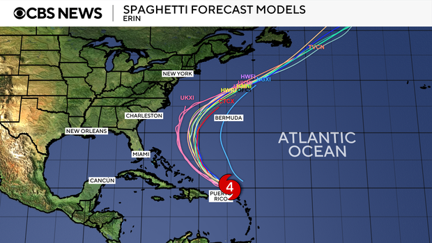
“All of our best consensus aids show Erin turning safely east of the United States next week, but it’ll be a much closer call for Bermuda, which could land on the stronger eastern side of Erin,” he said.
2025 Atlantic hurricane season so far
Erin is the fifth named storm of the 2025 Atlantic hurricane season, which started June 1 and runs through November 30.
So far, Tropical Storm Chantal is the only storm to have made landfall in the U.S., bringing deadly flooding to North Carolina in early July. In June, Barry made landfall as a tropical depression on Mexico’s eastern coast.
Forecasters could see conditions were ripe for Erin to become an extremely powerful storm as it moved across very warm waters in the open Atlantic.
“Water temperatures at the surface and hundreds of feet deep are several degrees higher than the historical average,” said Alex DaSilva, Accuweather’s lead hurricane expert.
This year’s season is once again expected to be unusually busy. The forecast calls for six to 10 hurricanes, with three to five reaching major status with winds of more than 110 mph.